Thursday, July 30, 2015
FORT ROBINSON, Northwest Nebraska
Fort Robinson was constructed and staffed in 1874 to monitor the distribution of supplies and beef promised to the Sioux Indians in return for peace. The fort worked to protect the Red Cloud Agency that had been set up by the Native Americans. In addition, because the area of the Platte River Valley had become a hotbed of chaos, the soldiers sometimes were called to duties involving cowboys from the Texas Trail, gold prospectors, and usually peaceful pioneers passing through Scotts Bluff. The cleft in the foothills of the Rockies to the west called Scotts Bluff was only a few miles away.
The fort's lands comprised 22,000 acres and were used in diverse ways over the long period it was staffed. It saw Indian clashes, including the killing of revered leader Crazy Horse, the first black troopers to be deployed there, military training and training of canines for war service, and the Remount Program where quality stallions were sent to the fort to be bred with suitable mares to improve cavalry stock. The troopers found the fort to be pleasant duty and, in their spare time, founded a Polo team.
Today the fort is a state park. The building shown above was the enlisted men's quarters and now houses visiting tourists. It has a dining room and gift shop today. One can board owned horses in the former cavalry barns for a fee -- a sort of horse motel. A swimming pool, wonderful hiking in rolling, pleasant, treed countryside, and visits to the many existing and well-maintained fort buildings are among the popular attractions. This scenic part of Nebraska has rugged river beds, huge ranches in the Sand Hills country, buttes and valleys inviting exploration.
Wednesday, July 22, 2015
ODD SAND HILLS OF NEBRASKA NORTH OF PLATTE RIVER
FAMOUS SAND HILLS OF NEBRASKA
This view is near Chadron at the northwest edge of the hills.
I had no idea that, as we drove west along the North Platte on
#26 and north on #385, we bordered one of the Midwest's most famous areas. The
rolling hills look like just another extension of more modest hills and plains.
Wrong! The 20,000 acres of Sand Hills in the north of the Platte Valley lie
atop the Ogallala Aquifer of 172,000 square miles that provides drinking water
and irrigation water to portions of eight adjoining states. No wonder the grass
is green in spring.
When I saw the hills in 2015, I realized I had driven
through them about 10 years ago on an assignment in Kansas and South Dakota. I
had been surprised by the virtual wilderness of grassy hillocks and hills, punctuated
by ponds and smallish lakes along the winding road. For many miles I saw
nothing but grass and water and wondered about it. Clearly, I had been driving
through the Sand Hills.
Perhaps 8,000 years ago the hills were, indeed, sand or alluvial
deposits left by receding glaciers and a major drought. The complex terrain was
and is wonderful for an array of wild animals but, when farmers looked at it in
the 1800s, they found the surface land so shallow that cultivation was not
practical. The sand or dust would simply blow away, creating a vast desert. Late in the 1870s, though, ranchers found it
made outstanding grazing land for special animals -- cattle that also became
quite wild, roaming the thousands of grassy acres. Large ranches prospered and
still do, although fewer. One can
imagine cowboys loping through the tall grass between ponds and lakes that
made roundups challenging.
The unusual and specialized lands are thought to be the
largest sand dunes in the Western Hemisphere and were designated as a National
Natural Landmark in 1984. I am sure the Conestoga wagoneers heading west to the
Columbia River avoided them totally.
Wednesday, July 15, 2015
EMIGRANTS ROLL ALONG THE NORTH PLATTE RIVER
Familiar to most who have studied about the Oregon Trail is CHIMNEY ROCK
The old Oregon Trail is studied by most people with a beginning
at Independence on the Missouri River, today a part of the Kansas City extended
area. The emigrant's route followed the Missouri north and veered westward
along the Platte River. From its headwaters in Jackson County, Colorado, near
the border of Wyoming, a rugged site in the Rocky Mountains., the river now
known as the North Platte had merged with the lesser South Platte near today's
town of North Platte, more than 700 miles later, and flowed eastward as one. Thus, the pioneers
were traveling upstream all the time, whether headed for the Columbia River or
toward California on the South Platte.
Familiar to anyone reading about the pioneers and the Oregon
Trail or Mormon Trail are rock formations such as Chimney Rock and the Scott's
Bluff itself. Indians plagued some
trains, more curious and interested in what objects or foods they could get
from the trains than in killing the emigrants. With dread of the Indians and
misinformation the emigrants were not the friendliest of travelers, either. One
might feel sad that the early mingling of two (or more) racial groups and
cultures that the days did not go better. An Indian friend of mine once
commented to me that displacement of one people by another had been going on
forever. I am not sure that makes it any easier to bear.
Disease and accidents were big killers of emigrants, lack of
food and water, too, with virtually no medical care among the travelers.
Well-known are accounts of throwing away of much too heavy furnishings along
the trail or of the breakdown of over-challenged horses or oxen (pioneers found
that slow oxen proved more durable than fast horses). So it was when the
emigrants began to reach the upper limits of the Plains and face the rugged
country between them and the Columbia River of Oregon and the green, watered
pastures of the Willamette country.
What few accounts of the trails relate is the unusual land
adjacent to the North Platte route -- the Sand Hills of Nebraska. See the next
blog.
Thursday, July 9, 2015
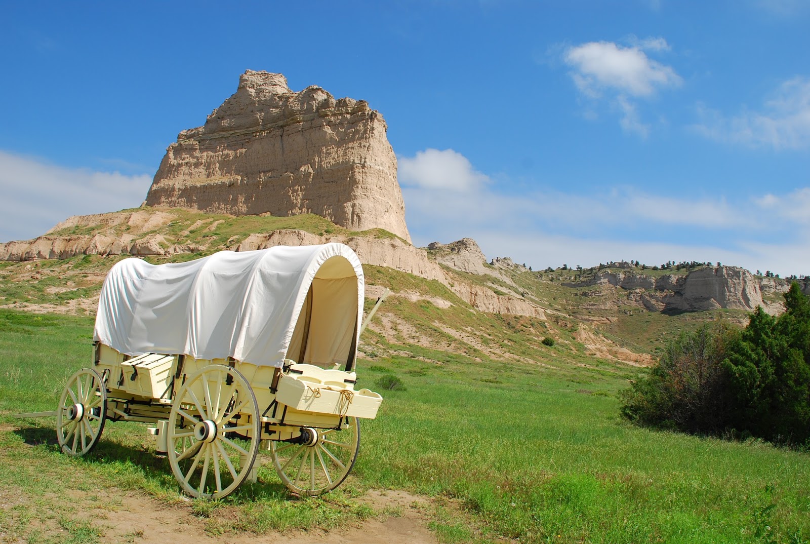
EMIGRANT WAGONS AS EARLY AS 1841.
The lone wagon shown against Scott's Bluff is the type that had to be lowered over Windlass Hill. See text below.
We have talked about Ogallala and Sidney to explain the
relationship to the westward movement as being in the middle of an area along
the North and South Platte rivers . Here geography resulted in the ongoing
arrival of future residents of the Pacific coastal states via the Columbia
River (pretty much straight west of the Platte) and California via the Mohave
Desert and plains. We need to backtrack a bit to the earlier 1800s.
In the beginning, the valley of the Platte was a logical
entry through the increasingly rugged sets of buttes and mountains that must be
overcome. As early as the 1820s fur trappers, most of them traveling alone or
in small groups, used the Platte as the route to the Rocky Mountains to look
for beaver. Beaver hats popular with wealthy Easterner dudes and, even more,
perhaps, British "toffs." created a booming market for beaver fur.
The Native Americans,
however, were increasingly concerned
about the inroads of pioneers into their hunting grounds. William Ashley and
his men began to use the Platte corridor to avoid the Lakota and Cheyenne
tribes with homelands more to the north from 1824 to 1827. In 1832, Benjamin Bonneville successfully
traveled through the Platte area and built a trading camp or small fort in Wyoming that was
a failure. However, Bonneville continued on to the Columbia River, where Fort
Astor and later Fort Vancouver were operated by Hudson's Bay people and viewed
him rightly as a competitor. Bonneville proceeded then to explore the
California cutoff trail that emanated at the junction of the North and South
Platte of today's Nebraska. It tended to follow what is today I-80, formerly
the Lincoln Highway, first transcontinental highway.
You have heard of the "Green Mountain boys" These
were Rocky Mountain area trappers who decided to have an annual sort of trade
fair, where potential buyers and sellers (usually individuals or small
partnerships) met somewhere in the Rockies to trade, usually Wyoming. These affairs
turned out to be for riotous living, drinking, meeting females (mostly local
Indians smitten with gifts of goods never before imagined). More business
minded, Ashley used 10 mule-drawn wagons and 81 men to protect the booty to
cross the Wind River Mountains, and reported to the government of the
feasibility of such travel.
The first known party to travel through the Platte Valley
was the Bidwell-Bartleson Party in 1841. The wagon trains would continue to
bring new western residents toward the Pacific until after the transcontinental
railroad was completed to their destinations in 1869. Wagons continued to roll
in ever fewer numbers but on through the 70s, thus mingling with gold
prospectors and cattlemen in the Platte area for awhile.
During my recent explorations of the North Platte and
northwest corner of Nebraska area, I visited with keen interest a wagon train
barrier that became known as Windlass Hill at what is now called Ash Hollow
State Historical Park. The name "Windlass" says it all. It was a deep
valley where emigrant wagons and teams were stumped for awhile. They figured
out how to lower the wagons into the valley by fastening them to teams of oxen
at the top of the slope or to strong men and ropes, thus slowing the descent to
a manageable speed and avoiding damage. Once down into this verdant, spring-fed
valley of green grass and one of the only tree groves in the surrounding area,
the travelers tended to hang out there for several days to rest, maybe dance a
little, and let their teams of oxen or horses fill their bellies with good
grass The valley continued as part of the Oregon Trail route. Today the hill still
shows ruts from all those wagon wheels down the slope. Like me, many were
thrilled to walk in or near the ruts "drug out of the dirt" fully 175
years ago! In one case, a ravine maybe
five feet deep has resulted, path for water drainage or collection, but mostly
the ruts are shallow. As an historical park, a walkway has been provided all
the way to the top of the slope. In 2015 during the seemingly endless rainy
spring the place was a paradise of greenery. Can't you just see the hot, tired
travelers stretched out on the grassy hillside and hear their laughter and
banter as they relaxed, cooked, sewed their clothes, repaired damaged wagons,
and enjoyed the relief to be down a stern barrier looking westward?
(Windlass Hill or Ash Hollow site is not far south of
today's Lake Mcconaughy or village of Lewellen.)
Tuesday, June 30, 2015
SIDNEY, NEBRASKA, 1870S TOUGH PIONEER CROSSROADS
The TRAIL BOSS was able to control his cowboys on the Texas Trail but, when they had shipped the herds, look out as they let off steam. They were not alone. Railroad crews, transient gunmen, seasoned explorers, gold seekers, and determined pioneers heading for land along the Columbia River were in the mixture of temporary residents of Sidney in the later1800s. One can imagine the results.
An estimated 48 to 76 bordellos lined the dusty, muddy paths they called streets. Disagreements were settled by bullets. Reckless gunplay could include shooting at a person just to see how close you could come without actually hitting him. One reported gunman delighted in shooting at melons offered for sale on a makeshift table, but hit the salesperson, instead. The sheriff was accused of being on the side of the bad guys.
Passengers on the Union Pacific Railroad were advised not to get off at Sidney. Eventually, the doors of the trains were locked and no one could leave. Finally, 64 of the town's upstanding citizens had enough and issued the notice excerpted here:
All murderers, thieves, pimps, and slick-fingered gentlemen .. must go. They are given due notice to do so, Law and order must henceforth prevail. The law will guide us where the law is possible; where it is impossible the power of right will be invoked.
Well, it WAS invoked. Authorities rounded up the worst of the lot, who included a seven-foot rowdy named Red McDonald, and hung hem high on the trees next to the railroad, where passengers could see the results of the change in Sidney. The Trail Boss above may be pondering the fate of those buried on Boot Hill, a place where -- years later -- four skeletons were found, thought to be four others of the worst.
A good thing, too, despite the fact that, less than three years later, the largest gold bullion robbery in the USA to that time was in Sidney. The gold arrived on a stagecoach from the Dakotas and, during the transfer time, simply disappeared.
Today the lively small town of Sidney is home to the World Headquarters of the outdoor supplies manufacturer Cabela's, with its stores springing up swiftly. Citizens live peacefully as one would expect in Nebraska, and travelers go both ways through the gap that saw so many travelers headed toward the Pacific or the Columbia River country in the 1800s
Thursday, June 25, 2015
A CHAOTIC MIXTURE OF PEOPLE IN CENTRAL NEBRASKA
Sidney NEBRASKA!! I called it Sidney, Alaska, within the last post! As a Western Washington writer, I guess my brain typed Alaska as more familiar. Apologies to all concerned. Embarrassed blogger, JoAnn Roe.
-----
This sculpture is on a pleasant green in front of the world headquarters of Cabela's at Sidney, NEBRASKA, the outdoor store that is succeeding so swiftly. On my recent trip we flew into Denver, Colorado, and drove north to Sidney, a few miles south of the North Platte River for an overnight at Sidney Lodge. From there we could turn east to Ogallala the following day. I need to set the stage for traveling the North Platte River paths.
The routes west in the mid-1800s, before the transcontinental railroad, depended on where travelers crossed the Missouri River . We won't get into that saga here, but only say that those coming west tended to follow trails that converged on Fort Kearny and continued up the North Platte River, becoming routes known as the Oregon Trail, the Mormon Trail, or sometimes just called the Overland Trail.
We will talk more about the Wild and Woolly West in the next post, but here I must explain why we were bound east to Ogallala before we turned back to the West.
From about 1875 to 1885, Ogallala was the northern terminus of the Texas trail so familiar to those who viewed the movie and TV series, "Lonesome Dove." Texas ranch employees drove their cattle herds to Ogallala to put them on the Union Pacific Railroad bound for eastern markets, and to sell some stock to the growing number of ranchers in Nebraska, Wyoming and Montana. One can only imagine the chaos in Ogallala when the dusty, tired, thirsty and lonely cowboys from Texas and in between were finally free of the cattle herds. And your imagination seldom will be as lurid as the real happenings.
Sidney was equally important because, when gold was discovered in the Dakota country by Custer, the prospectors turned north at Sidney from the east-west trail toward hopeful prosperity from gold discoveries. As the transcontinental railroad marched westward through Sidney, railroad workers, gold seekers, cowboys and pioneers became a volatile mix. Adding to the mayhem were Indians (or Native Americans) angry that the U.S. Government was not meeting its promises of sufficient beef to feed their people and the intrusion of gold seekers. Clashes among humans became as intense as the elk bull battles depicted above.
We will talk about it in a couple of days from now....
Tuesday, June 23, 2015
NEBRASKA THE GATEWAY TO THE COLUMBIA RIVER
Endless, almost electric green acres rolled on to the horizon in north central Nebraska, where fields from South Dakota virtually joined those of its southerly neighbor. It was what I expected. As we drove on west, everything changed. Hills turned into ridges, and the Platte River tributaries laced through the ever more rugged southwest Nebraska lands. Buttes of needle like stature rivaled my memory of Arizona or New Mexico, leaping from the green earth like aliens seeking to appear from some subterranean city. This was Nebraska???
Nebraska was the center of westward movement toward the mysterious and distant Pacific Ocean. It hosted Texans like those in the popular "Lonesome Dove" who drove half-starved cattle north to Ogallala west of Omaha to ship them east to feeder markets on the only railroad in the Prairies for awhile, or sold them to pioneers sprinkled across adjacent Wyoming, South Dakota, and parts of Colorado. What was not evident at first was that the road to Oregon's Willamette Valley or eastern Washington grassland lay virtually straight west from this lonely chunk of fertile land -- north central Nebraska.
The route west lay along the large, shallow, and curving North Platte River and its cousin the South Platte. It would lead explorers, fur seekers who eventually got rich if not dead, and bonnet-clad women and children to a hoped-for verdant land. Some 70,000 Mormons passed through on the way to religious freedom in Utah. Hardy gold-seekers turned north to the Dakotas to look for gold. They passed familiar landmarks that still loom today, such as the Courthouse and Jail Rocks, Chimney Rock and Scott's Bluff on what became known as the Oregon Trail and the Mormon Trail, the Oregon-California cutoff, and became cursed, as well, by thirsty and hungry pilgrims.
I had the privilege of tracing the unusual charms and challenges of this unusual Nebraska just recently. I will bring you along in subsequent posts and pictures. Above is a pony express rider at Sidney, Alaska, where the 150th birthday of the colorful group was celebrated in 2010. Get your horse or your Conestoga in your mind and follow me. Yee Haw! JoAnn Roe, author of The Columbia River (Caxton Press, 2013)
Subscribe to:
Posts (Atom)