I remember talking to a Columbia River ship captain who said he once tied his boat/ship to his own house along the river near The Dalles when the river froze to a depth of 5-6 feet in 1949! It remained until the wind switched around from N/NE to the usual warmer SW winds. I believe this has never happened since.
Also in winter at the Canadian bend of the river from NW to SW, snow in the 1940s covered construction equipment so deeply that a small aircraft had to fly over and identify where it was. It seems unlikely today to believe these stories of the river before many dams and climate variations.
My book on the Columbia River tells the stories of real people and life, as does the book San Juan Islands: Into the 21st Century, both published in the last few years. Just today in the San Juans, the much loved Christmas Ship had to cancel its voyage through the San Juans and some of the Canadian Gulf Islands because of strong winds. It is not only the winds that cause trouble sometimes, but the combination of winds and currents.
Usually both locations are tranquil places to enjoy cruising along in river boats or Salish Sea boats. Salish Sea is the newest name for the waters of Puget Sound and north of the Washington-BC border.
MERRY CHRISTMAS TO ALL WHO ARE SAFE IN THEIR HOMES OR CABINS DURING OCCASIONAL RUGGED WINTER WEATHER.
Saturday, December 12, 2015
Friday, November 13, 2015
GOOD NEWS FROM COLUMBIA RIVER

The salmon are swimming upstream to spawning grounds in record numbers right now, and many are swimming in the waters above !!! Good news, indeed. The news from authorities is that perhaps as many as twice last year's salmon are fighting their way up river. An increasingly healthy river?
It is true that no one, really, can accurately predict in advance what any given year will be good. Even before dams, marauders like sea lions, or pollution problems were faced, the salmon runs historically have varied sharply from year to year. It is my impression that -- since the salmon decide to come up river from broad areas of the Pacific Ocean, where they have been hanging out after reaching the ocean from the Columbia River and its tributaries -- who could possibly know for sure. I don't mean to disparage your skills, dear fish experts. We can just enjoy this year a bumper "crop" of returnees.
Unfortunately for them, the returning salmon who left as juveniles will die after they reach their original homes after first laying their eggs in the rivers and streams. But that is Mother Nature's way: the bodies they sacrifice at this point will nourish myriads of birds and animals that depend on their gift for survival.
Several times in my life I have visited and watched the salmon fighting against the current and manmade obstacles, or fleeing from hungry sea lions or animals or birds to complete heir life cycle by depositing their eggs so far from the ocean. It is really quite impressive, even emotional to watch.
Thursday, October 15, 2015
COLUMBIA GORGE

One reason for installing the dams on the upper river, north of the US border, was to control seasonal high water periods. Imagine Portland residents far down river from Canada traveling the city streets in rowboats Yes, that did occur.
The pioneers who began their journey in Nebraska to and through the Columbia Gorge to the greenery of Oregon came down the waters above by raft and makeshift boats and left to trek a bit south of Portland to the pasture-like lands they settled. Others had abandoned river travel and struggled, wagons and all, over the Cascades Mountains south of the Columbia, so steep near Mount Hood that some fastened entire trees to the backs of the wagon to slow their descent into western Oregon lands.
Today western Oregon is a verdant plain from the Columbia south to about the city of Eugene, after which smaller mountains blocked southward travel intermittently all the way to California's valleys. Refer to a map of modern Interstate 5, the north-south freeway that runs from Canada to Mexico for orientation. The California bound pioneers that had split off way back in Nebraska approached it over mountain ranges, as well, such as the towering Sierras. Pioneers were not a faint-hearted lot. In my book, Columbia River (Caxton, 2013) you may read about real people of that time traveling westward or down the entire river, including the first 440 miles in Canada from birth to when it entered the United States.
Thursday, September 24, 2015
DREAMING OF OREGON & COLUMBIA RIVER

The tired pioneers bound on the Oregon Trail finally arrived in today's eastern Washington at the Columbia River. It was not like coming from the Midwest to shirtsleeve weather, because, for many, it was winter. Snow then fell along the river frequently, until the westbound traveler was well beyond the Cascades Range that stands north/south between The Dalles and Portland, and from Canada almost to Mexico.
A diary of a pioneer woman told of how some of her family had ridden the rapid-strewn Columbia River. However, she was walking along the river with her infant son, shivering and her feet like lumps of ice. I am sure she was wondering why they had come all this way, only to suffer so bitterly. At the time the migration wagons stopped at the river's edge or long before, and rafts on the river or one's own two feet were the transportation means.
Many of the pioneers put their wagons (minus their wheels) onto flimsy rafts that collapsed in the first of the river's many rapids and sank. A railroad group soon struggled to extend a crude train eastward from Portland or Vancouver, but it took time to manage an easy way for anyone traveling through the rugged Columbia Gorge. Those fortunate pioneers who made it in more favorable weather now were in temperate, green pastures south of the Columbia River in the Willamette country of Oregon, thanking the Lord they made it. Read about it in my late 2013 published book, Columbia River.
While I was passing along the North Platte, skirting such historic places as Chimney Rock and Scotts Bluff**, the reality of the challenges of our forefathers moving west to seek farmland and homes for their young-uns was driven home in the contrast of my travel by comfortable van. And rightfully indignant native Americans already living along these trails were not there to threaten me, either.
**Scottsbluff, Scott's Bluff, Scotts Bluff all are spellings for this area.
Saturday, September 19, 2015
YOUR CONESTOGA CAME THROUGH HERE
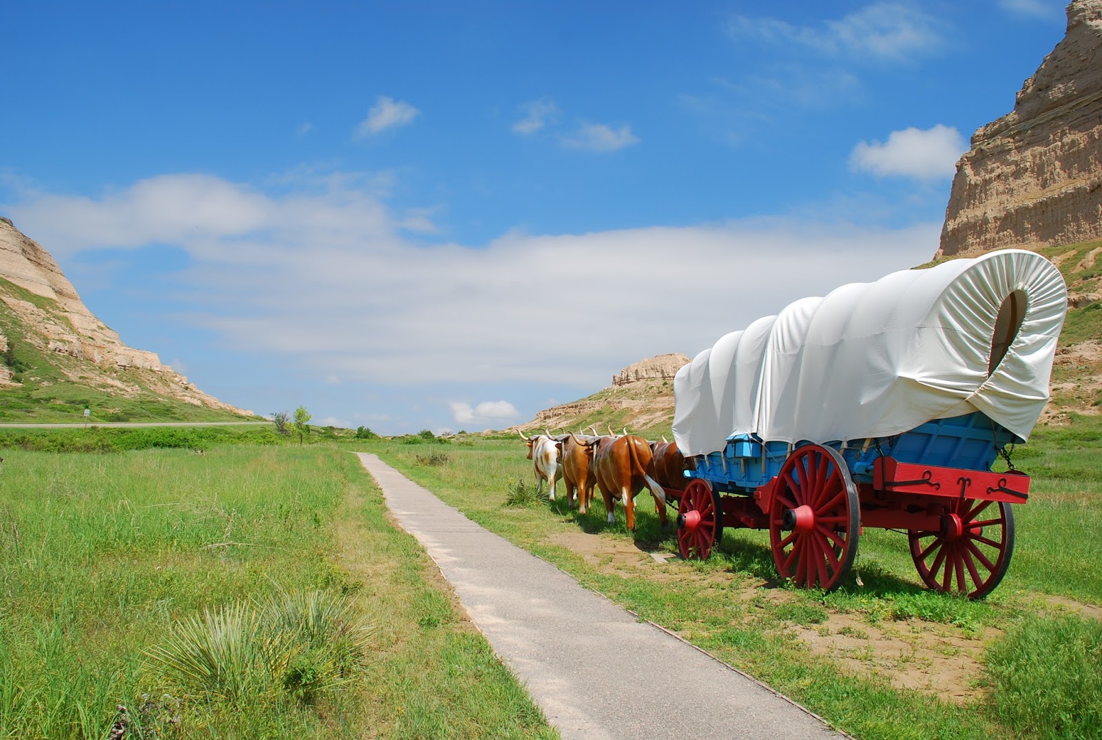
Initially, the earlier days pioneers tended to travel through the buttes a bit north at Robidoux Pass, because the approach pictured here had some difficult gullies and ravines east of the opening. They were filled in sometime in the 1840s or early 1850s, and thereafter travelers used the one shown. Robidoux was a trader in furs and some supplies to the east of the pass.
Thousands of pioneers came through this openin in the mid- 1800s , possibly some of your own relatives, bound for Oregon's fertile Willamette Valley or eastern Washington, or even Wyoming and Montana (lesser numbers).
Today you can drive in your heated or air-conditioned car along major highway #26 to imagine your ancestor's trip through today's Nebraska along the Platte River -- here at Scotts Bluff the North Platte. He/she probably prevented starvation some days by eating hardtack, Believe me, it resembles a piece of bread that had been run over by the wheels of your Conestoga wagon a month ago!. I sampled one, hoping my teeth would not break off in the process. It was created by just flour and water, plus salt, perhaps.
Friday, September 4, 2015
PONY EXPRESS IN NEBRASKA

THE PONY EXPRESS IN NEBRASKA
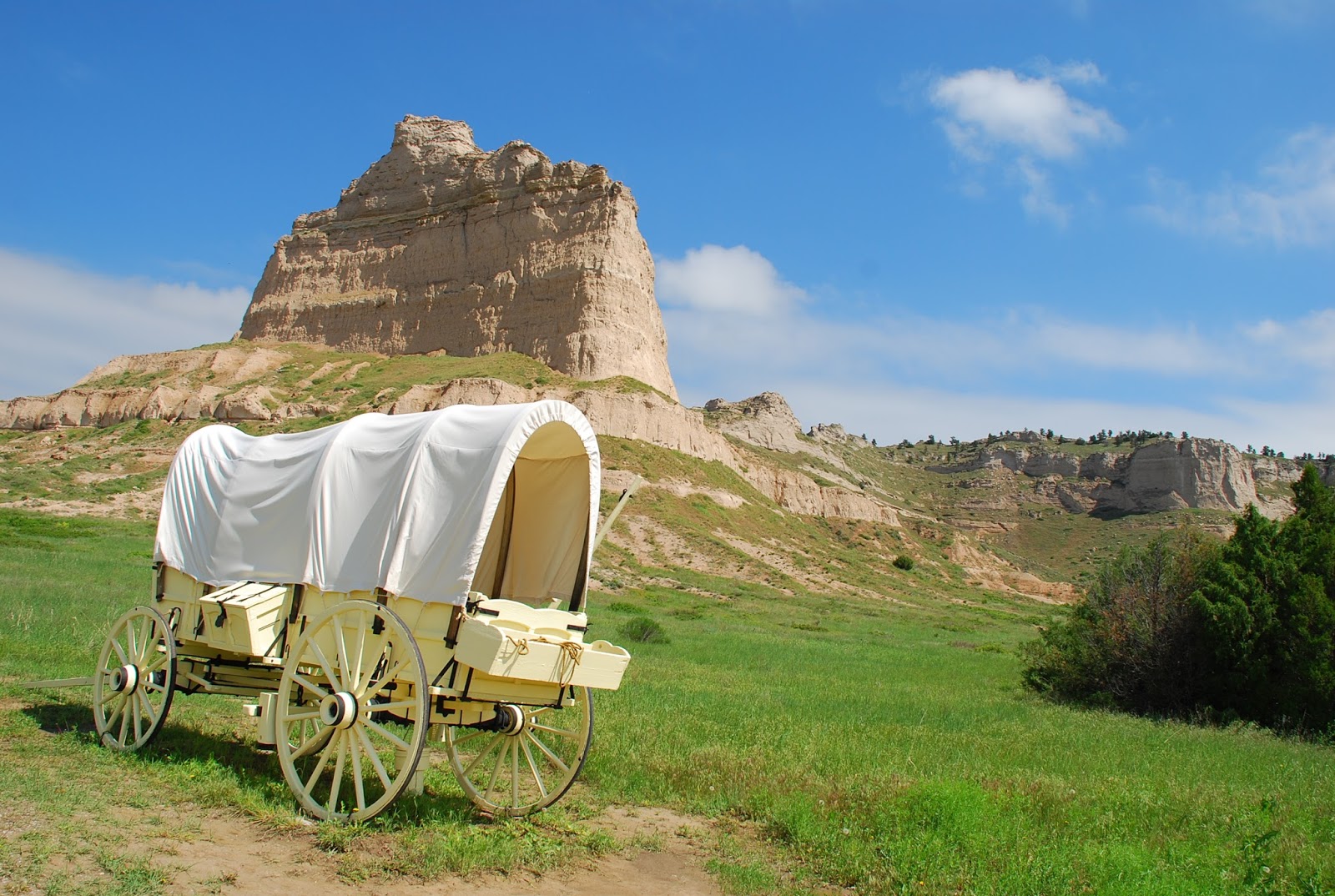
When I was in Nebraska recently, I was taking photos of
Scott's Bluff and admiring replicas of Conestoga wagons. Suddenly the sound of hoofbeats
thundered toward the area. As a lifetime horse owner, it could only be one
thing. But why? Within minutes two
western-clad men on horses in full
gallop came into the grassy place where I was standing, along with several
other startled visitors.
As they skidded to a stop nearby, I realized they were 2015
Pony Express riders re-enacting a segment of their 1860-61 rides. The two
children pictured above were overwhelmed by the spectacle, restrained by their
father and mother from dashing to the horses. The little boy was speechless,
but the two children soon ventured close enough to the horse that its
dismounted rider said, "It's okay, you can pet him right there." For
fully 30 minutes the two riders explained
the history of the Pony Express period to an ever-larger impromptu
audience.
In 1860 the continental telegraph lines had not yet been
completed. Mail across this vast nation of ours was slow. A westerner often did
not learn what was happening "back East" for weeks. Gold had been
discovered in California and a strong movement existed toward the
Western states, especially California and Oregon. In Oregon settlers in wagons aimed for good land along
the Columbia River north of today's Portland,
A private firm in 1860 established what became known as the
Pony Express, where brave young riders, mostly of minimal weight and
experienced with horses rode in relays to bring the mail from St. Joseph,
Missouri, to Sacramento, California (and on to San Francisco by river steamer) in
half the time it had taken by stagecoach -- 10 days instead of 20. It
operated only from April 3, 1860, until
October 24, 1861, but it won the romantic hearts of all Americans. By 1861, the
telegraph wires had reached the far west.
The 2,000-mile Pony Express route ran through most of the
state of Nebraska. No wonder the children pictured here would view the riders
as their heroes of their home state.
Friday, August 21, 2015
REPLICA OF A PIONEER TOWN IN REMOTE NW NEBRASKA

In the summer of 2015, I spent five days exploring the extreme NW corner of Nebraska, where it adjoins Wyoming and South Dakota's Black Hills . The terrain was extremely rugged, nothing like the stereotypes of Nebraska's lush farmlands. Ranchers like the man pictured ran cattle over the irregular lands, and some began to offer visitors a place to stay or visit or dine.
To get to this chopped up, scenic land, a driver leaves a paved road far behind for a graveled road that goes across a very wide wash (river bed) that is the geologic remnant of a vast primitive waterway. In its turbulent periods the river currents and erosion left tufts of land that vary from a conference table size to a lawn-sized little mesa. The mostly vertical sides of such little pieces of land resemble the toadstools of elsewhere in the area.
This is the High Plains Homestead, a small but excellent restaurant, a very western cocktail lounge and limited overnight rooms, all in a complex like a western village.Quite charming. A visiting geology professor says the landscape and rocks of the area resulted from the creation and subsequent erosion of the Rocky Mountains to the west.
I am told that other scattered ranchers of the area also are catering to tourists, too, in differing ways. Guess you and we will have to do more exploring in this unusual part of the West.
Tuesday, August 11, 2015
TOADSTOOL PARK IN NEBRASKA

Before setting off on the hike, visitors have a picnic and stoke up on water.
August 11, 2015
This astonishing country in Northwest Nebraska continues to
fascinate me, as it is more like New Mexico than the image of a green farming
state that most have. From my last blog at Hudson-Meng, it is only a three-mile
scenic hike to Toadstool Park.
After arrival and a visit to the restroom, grab a sandwich
and water from one's pack (nothing but the restrooms exist there), and enter
the park to walk a one-mile, interpretive trail to see the weird formations.
Big slabs of rock like giant skipping stones are balanced on fragile-looking
supports. Some are stacked like M&Ms Others lie at such an angle that they
appear to be about to slide off into a canyon.
Basically, the rough country was slashed open by a huge
flood or prehistoric river. It became
covered with volcanic red dust blown all the way from the Oregocountry, then eroded by wind and rain into today's
bizarre shapes. Fossils are often visible, but visitors are forbidden to remove
them.
Tuesday, August 4, 2015
ARCHAEOLOGIST'S DREAM

Northwestern Nebraska is totally different from the expected scenery of rolling green hills and farms with few trees, as I have said in previous blogs. In the extreme northwest corner between Wyoming and South Dakota craggy buttes rise up and continue into (or from) the Black Hills of South Dakota. A true badlands exists.
Depicted here is a display within Hudson-Meng Research Center northwest of Crawford and Highway 20. In the area only a few years ago, an unbelievable bed of bison bones was found under the greenery of Oglala National Grassland that is one of the most important discoveries of archaeology and paleontology in the entire United States, The bones of at least 600 bison of a different type from the current bison that you might see at Yellowstone Park are 10,000 year old remains, making the site the largest extinct bonebed in the world. A sample was gathered to place inside the research center for the public to see. Bones of a very few other creatures were mixed into the site, and -- of all things - an ancient knife.
The bones were excavated during 1971-77 by students from nearby Chadron State College. The research center is tiny and remote, situated along a pleasant, running stream bed, a building about the size of a two-bedroom house. You may be sure the studies will reveal more about the ancient hunters.
Fossils and odd rock formations at Toadstool Geologic Park are a day's hike distant, although both areas are accessible from gravel roads. Food and lodgings are several miles from either location. Read the next edition of this adventure in about a week.
Thursday, July 30, 2015
FORT ROBINSON, Northwest Nebraska

Fort Robinson was constructed and staffed in 1874 to monitor the distribution of supplies and beef promised to the Sioux Indians in return for peace. The fort worked to protect the Red Cloud Agency that had been set up by the Native Americans. In addition, because the area of the Platte River Valley had become a hotbed of chaos, the soldiers sometimes were called to duties involving cowboys from the Texas Trail, gold prospectors, and usually peaceful pioneers passing through Scotts Bluff. The cleft in the foothills of the Rockies to the west called Scotts Bluff was only a few miles away.
The fort's lands comprised 22,000 acres and were used in diverse ways over the long period it was staffed. It saw Indian clashes, including the killing of revered leader Crazy Horse, the first black troopers to be deployed there, military training and training of canines for war service, and the Remount Program where quality stallions were sent to the fort to be bred with suitable mares to improve cavalry stock. The troopers found the fort to be pleasant duty and, in their spare time, founded a Polo team.
Today the fort is a state park. The building shown above was the enlisted men's quarters and now houses visiting tourists. It has a dining room and gift shop today. One can board owned horses in the former cavalry barns for a fee -- a sort of horse motel. A swimming pool, wonderful hiking in rolling, pleasant, treed countryside, and visits to the many existing and well-maintained fort buildings are among the popular attractions. This scenic part of Nebraska has rugged river beds, huge ranches in the Sand Hills country, buttes and valleys inviting exploration.
Wednesday, July 22, 2015
ODD SAND HILLS OF NEBRASKA NORTH OF PLATTE RIVER

FAMOUS SAND HILLS OF NEBRASKA
This view is near Chadron at the northwest edge of the hills.
I had no idea that, as we drove west along the North Platte on
#26 and north on #385, we bordered one of the Midwest's most famous areas. The
rolling hills look like just another extension of more modest hills and plains.
Wrong! The 20,000 acres of Sand Hills in the north of the Platte Valley lie
atop the Ogallala Aquifer of 172,000 square miles that provides drinking water
and irrigation water to portions of eight adjoining states. No wonder the grass
is green in spring.
When I saw the hills in 2015, I realized I had driven
through them about 10 years ago on an assignment in Kansas and South Dakota. I
had been surprised by the virtual wilderness of grassy hillocks and hills, punctuated
by ponds and smallish lakes along the winding road. For many miles I saw
nothing but grass and water and wondered about it. Clearly, I had been driving
through the Sand Hills.
Perhaps 8,000 years ago the hills were, indeed, sand or alluvial
deposits left by receding glaciers and a major drought. The complex terrain was
and is wonderful for an array of wild animals but, when farmers looked at it in
the 1800s, they found the surface land so shallow that cultivation was not
practical. The sand or dust would simply blow away, creating a vast desert. Late in the 1870s, though, ranchers found it
made outstanding grazing land for special animals -- cattle that also became
quite wild, roaming the thousands of grassy acres. Large ranches prospered and
still do, although fewer. One can
imagine cowboys loping through the tall grass between ponds and lakes that
made roundups challenging.
The unusual and specialized lands are thought to be the
largest sand dunes in the Western Hemisphere and were designated as a National
Natural Landmark in 1984. I am sure the Conestoga wagoneers heading west to the
Columbia River avoided them totally.
Wednesday, July 15, 2015
EMIGRANTS ROLL ALONG THE NORTH PLATTE RIVER

Familiar to most who have studied about the Oregon Trail is CHIMNEY ROCK
The old Oregon Trail is studied by most people with a beginning
at Independence on the Missouri River, today a part of the Kansas City extended
area. The emigrant's route followed the Missouri north and veered westward
along the Platte River. From its headwaters in Jackson County, Colorado, near
the border of Wyoming, a rugged site in the Rocky Mountains., the river now
known as the North Platte had merged with the lesser South Platte near today's
town of North Platte, more than 700 miles later, and flowed eastward as one. Thus, the pioneers
were traveling upstream all the time, whether headed for the Columbia River or
toward California on the South Platte.
Familiar to anyone reading about the pioneers and the Oregon
Trail or Mormon Trail are rock formations such as Chimney Rock and the Scott's
Bluff itself. Indians plagued some
trains, more curious and interested in what objects or foods they could get
from the trains than in killing the emigrants. With dread of the Indians and
misinformation the emigrants were not the friendliest of travelers, either. One
might feel sad that the early mingling of two (or more) racial groups and
cultures that the days did not go better. An Indian friend of mine once
commented to me that displacement of one people by another had been going on
forever. I am not sure that makes it any easier to bear.
Disease and accidents were big killers of emigrants, lack of
food and water, too, with virtually no medical care among the travelers.
Well-known are accounts of throwing away of much too heavy furnishings along
the trail or of the breakdown of over-challenged horses or oxen (pioneers found
that slow oxen proved more durable than fast horses). So it was when the
emigrants began to reach the upper limits of the Plains and face the rugged
country between them and the Columbia River of Oregon and the green, watered
pastures of the Willamette country.
What few accounts of the trails relate is the unusual land
adjacent to the North Platte route -- the Sand Hills of Nebraska. See the next
blog.
Thursday, July 9, 2015
EMIGRANT WAGONS AS EARLY AS 1841.
The lone wagon shown against Scott's Bluff is the type that had to be lowered over Windlass Hill. See text below.
We have talked about Ogallala and Sidney to explain the
relationship to the westward movement as being in the middle of an area along
the North and South Platte rivers . Here geography resulted in the ongoing
arrival of future residents of the Pacific coastal states via the Columbia
River (pretty much straight west of the Platte) and California via the Mohave
Desert and plains. We need to backtrack a bit to the earlier 1800s.
In the beginning, the valley of the Platte was a logical
entry through the increasingly rugged sets of buttes and mountains that must be
overcome. As early as the 1820s fur trappers, most of them traveling alone or
in small groups, used the Platte as the route to the Rocky Mountains to look
for beaver. Beaver hats popular with wealthy Easterner dudes and, even more,
perhaps, British "toffs." created a booming market for beaver fur.
The Native Americans,
however, were increasingly concerned
about the inroads of pioneers into their hunting grounds. William Ashley and
his men began to use the Platte corridor to avoid the Lakota and Cheyenne
tribes with homelands more to the north from 1824 to 1827. In 1832, Benjamin Bonneville successfully
traveled through the Platte area and built a trading camp or small fort in Wyoming that was
a failure. However, Bonneville continued on to the Columbia River, where Fort
Astor and later Fort Vancouver were operated by Hudson's Bay people and viewed
him rightly as a competitor. Bonneville proceeded then to explore the
California cutoff trail that emanated at the junction of the North and South
Platte of today's Nebraska. It tended to follow what is today I-80, formerly
the Lincoln Highway, first transcontinental highway.
You have heard of the "Green Mountain boys" These
were Rocky Mountain area trappers who decided to have an annual sort of trade
fair, where potential buyers and sellers (usually individuals or small
partnerships) met somewhere in the Rockies to trade, usually Wyoming. These affairs
turned out to be for riotous living, drinking, meeting females (mostly local
Indians smitten with gifts of goods never before imagined). More business
minded, Ashley used 10 mule-drawn wagons and 81 men to protect the booty to
cross the Wind River Mountains, and reported to the government of the
feasibility of such travel.
The first known party to travel through the Platte Valley
was the Bidwell-Bartleson Party in 1841. The wagon trains would continue to
bring new western residents toward the Pacific until after the transcontinental
railroad was completed to their destinations in 1869. Wagons continued to roll
in ever fewer numbers but on through the 70s, thus mingling with gold
prospectors and cattlemen in the Platte area for awhile.
During my recent explorations of the North Platte and
northwest corner of Nebraska area, I visited with keen interest a wagon train
barrier that became known as Windlass Hill at what is now called Ash Hollow
State Historical Park. The name "Windlass" says it all. It was a deep
valley where emigrant wagons and teams were stumped for awhile. They figured
out how to lower the wagons into the valley by fastening them to teams of oxen
at the top of the slope or to strong men and ropes, thus slowing the descent to
a manageable speed and avoiding damage. Once down into this verdant, spring-fed
valley of green grass and one of the only tree groves in the surrounding area,
the travelers tended to hang out there for several days to rest, maybe dance a
little, and let their teams of oxen or horses fill their bellies with good
grass The valley continued as part of the Oregon Trail route. Today the hill still
shows ruts from all those wagon wheels down the slope. Like me, many were
thrilled to walk in or near the ruts "drug out of the dirt" fully 175
years ago! In one case, a ravine maybe
five feet deep has resulted, path for water drainage or collection, but mostly
the ruts are shallow. As an historical park, a walkway has been provided all
the way to the top of the slope. In 2015 during the seemingly endless rainy
spring the place was a paradise of greenery. Can't you just see the hot, tired
travelers stretched out on the grassy hillside and hear their laughter and
banter as they relaxed, cooked, sewed their clothes, repaired damaged wagons,
and enjoyed the relief to be down a stern barrier looking westward?
(Windlass Hill or Ash Hollow site is not far south of
today's Lake Mcconaughy or village of Lewellen.)
Tuesday, June 30, 2015
SIDNEY, NEBRASKA, 1870S TOUGH PIONEER CROSSROADS

The TRAIL BOSS was able to control his cowboys on the Texas Trail but, when they had shipped the herds, look out as they let off steam. They were not alone. Railroad crews, transient gunmen, seasoned explorers, gold seekers, and determined pioneers heading for land along the Columbia River were in the mixture of temporary residents of Sidney in the later1800s. One can imagine the results.
An estimated 48 to 76 bordellos lined the dusty, muddy paths they called streets. Disagreements were settled by bullets. Reckless gunplay could include shooting at a person just to see how close you could come without actually hitting him. One reported gunman delighted in shooting at melons offered for sale on a makeshift table, but hit the salesperson, instead. The sheriff was accused of being on the side of the bad guys.
Passengers on the Union Pacific Railroad were advised not to get off at Sidney. Eventually, the doors of the trains were locked and no one could leave. Finally, 64 of the town's upstanding citizens had enough and issued the notice excerpted here:
All murderers, thieves, pimps, and slick-fingered gentlemen .. must go. They are given due notice to do so, Law and order must henceforth prevail. The law will guide us where the law is possible; where it is impossible the power of right will be invoked.
Well, it WAS invoked. Authorities rounded up the worst of the lot, who included a seven-foot rowdy named Red McDonald, and hung hem high on the trees next to the railroad, where passengers could see the results of the change in Sidney. The Trail Boss above may be pondering the fate of those buried on Boot Hill, a place where -- years later -- four skeletons were found, thought to be four others of the worst.
A good thing, too, despite the fact that, less than three years later, the largest gold bullion robbery in the USA to that time was in Sidney. The gold arrived on a stagecoach from the Dakotas and, during the transfer time, simply disappeared.
Today the lively small town of Sidney is home to the World Headquarters of the outdoor supplies manufacturer Cabela's, with its stores springing up swiftly. Citizens live peacefully as one would expect in Nebraska, and travelers go both ways through the gap that saw so many travelers headed toward the Pacific or the Columbia River country in the 1800s
Thursday, June 25, 2015
A CHAOTIC MIXTURE OF PEOPLE IN CENTRAL NEBRASKA

Sidney NEBRASKA!! I called it Sidney, Alaska, within the last post! As a Western Washington writer, I guess my brain typed Alaska as more familiar. Apologies to all concerned. Embarrassed blogger, JoAnn Roe.
-----
This sculpture is on a pleasant green in front of the world headquarters of Cabela's at Sidney, NEBRASKA, the outdoor store that is succeeding so swiftly. On my recent trip we flew into Denver, Colorado, and drove north to Sidney, a few miles south of the North Platte River for an overnight at Sidney Lodge. From there we could turn east to Ogallala the following day. I need to set the stage for traveling the North Platte River paths.
The routes west in the mid-1800s, before the transcontinental railroad, depended on where travelers crossed the Missouri River . We won't get into that saga here, but only say that those coming west tended to follow trails that converged on Fort Kearny and continued up the North Platte River, becoming routes known as the Oregon Trail, the Mormon Trail, or sometimes just called the Overland Trail.
We will talk more about the Wild and Woolly West in the next post, but here I must explain why we were bound east to Ogallala before we turned back to the West.
From about 1875 to 1885, Ogallala was the northern terminus of the Texas trail so familiar to those who viewed the movie and TV series, "Lonesome Dove." Texas ranch employees drove their cattle herds to Ogallala to put them on the Union Pacific Railroad bound for eastern markets, and to sell some stock to the growing number of ranchers in Nebraska, Wyoming and Montana. One can only imagine the chaos in Ogallala when the dusty, tired, thirsty and lonely cowboys from Texas and in between were finally free of the cattle herds. And your imagination seldom will be as lurid as the real happenings.
Sidney was equally important because, when gold was discovered in the Dakota country by Custer, the prospectors turned north at Sidney from the east-west trail toward hopeful prosperity from gold discoveries. As the transcontinental railroad marched westward through Sidney, railroad workers, gold seekers, cowboys and pioneers became a volatile mix. Adding to the mayhem were Indians (or Native Americans) angry that the U.S. Government was not meeting its promises of sufficient beef to feed their people and the intrusion of gold seekers. Clashes among humans became as intense as the elk bull battles depicted above.
We will talk about it in a couple of days from now....
Tuesday, June 23, 2015
NEBRASKA THE GATEWAY TO THE COLUMBIA RIVER

Endless, almost electric green acres rolled on to the horizon in north central Nebraska, where fields from South Dakota virtually joined those of its southerly neighbor. It was what I expected. As we drove on west, everything changed. Hills turned into ridges, and the Platte River tributaries laced through the ever more rugged southwest Nebraska lands. Buttes of needle like stature rivaled my memory of Arizona or New Mexico, leaping from the green earth like aliens seeking to appear from some subterranean city. This was Nebraska???
Nebraska was the center of westward movement toward the mysterious and distant Pacific Ocean. It hosted Texans like those in the popular "Lonesome Dove" who drove half-starved cattle north to Ogallala west of Omaha to ship them east to feeder markets on the only railroad in the Prairies for awhile, or sold them to pioneers sprinkled across adjacent Wyoming, South Dakota, and parts of Colorado. What was not evident at first was that the road to Oregon's Willamette Valley or eastern Washington grassland lay virtually straight west from this lonely chunk of fertile land -- north central Nebraska.
The route west lay along the large, shallow, and curving North Platte River and its cousin the South Platte. It would lead explorers, fur seekers who eventually got rich if not dead, and bonnet-clad women and children to a hoped-for verdant land. Some 70,000 Mormons passed through on the way to religious freedom in Utah. Hardy gold-seekers turned north to the Dakotas to look for gold. They passed familiar landmarks that still loom today, such as the Courthouse and Jail Rocks, Chimney Rock and Scott's Bluff on what became known as the Oregon Trail and the Mormon Trail, the Oregon-California cutoff, and became cursed, as well, by thirsty and hungry pilgrims.
I had the privilege of tracing the unusual charms and challenges of this unusual Nebraska just recently. I will bring you along in subsequent posts and pictures. Above is a pony express rider at Sidney, Alaska, where the 150th birthday of the colorful group was celebrated in 2010. Get your horse or your Conestoga in your mind and follow me. Yee Haw! JoAnn Roe, author of The Columbia River (Caxton Press, 2013)
Monday, May 4, 2015
POWER TO THE SAN JUAN ISLANDS 1951
Just because we can see the San Juan Islands from several mainland shores does not mean it is simple to receive basic necessities. Major electrical power systems did not appear until 1951. The saga of power to the islands was fully described in my book, San Juan Islands: Into the 21st Century (late 2012).
Laying the cable from Anacortes underwater FIVE MILES to Decatur was not for the faint-hearted. Officials of Orcas Power & Light Company (OPALCO) believes it was the first such submarine cable operation within the United States. The cable emerged from saltwater at Decatur, went overland and then underwater again to Lopez to a sub-station. The cable had to be an unbroken length of at least 38,000 feet and, wound on 10-foot diameter reels, was sent to Fidalgo Island (Anacortes) on a series of rail gondolas chained together, making choice of rail routes extremely critical. Once on Fidalgo's ocean shore, crews transferred the huge reels to a special barge and unwound the cable to lie on the sea bottom, an uneven surface of highs and lows, boulders and sand.
Inevitably, tidal changes or big storms riled the hundreds-of-feet deep channels or ship or boat anchors accidentally picked up the cable and broke it. OPALCO's crews went out in any kind of weather to repair it, since -- of course -- that particular main cable break terminated all power to the then-settled islands.
I was particularly amused at the tale of one crew member. He told of going out to repair a broken cable, in this case not the main one but feeding just one island. He and the crew managed to find both ends of that cable down on the sea bottom, pulled it up on their boat, and respliced it (no small task) .
Only then as they prepared to drop the cable back into the water did they discover that, in retrieving one broken cable end, they had run it through a fixture on their boat!!!! They had to undo the entire splice, redo it, and then return it to the water! I suspect the air was turning blue around that boat!!!!
Monday, April 20, 2015
ODD MOMENTS IN ISLAND LIFE
The San Juan Islands of Washington are not that far from mainstream life. Yet they are islands that have a life of their own. Lying in the Salish Sea between Bellingham WA and Victoria BC, the islands are not convenient to access, except for four of the larger islands served by Washington State Ferry. A scattering of residents inhabit the other 168 islands that only are reached by private boat, one or two passenger boats (no vehicles) or by small plane.
In early years before the WS Ferry the islanders had to be more self-sufficient than now. In my books on the Northwest I like to tell the tales of odd moments in island life to make the so-called hard history more palatable. Among them is the story of Decatur Islanders who coexisted with totally wild sheep that had been abandoned decades ago by a farmer who moved away. In 1986 the current residents, mostly owners of small summer homes now, decided the sheep appeared in poor shape and decided to give them some TLC.
One man had a barn on his property, and the residents decided to round up the sheep and herd them into a fenced area to be treated for pests, to dock their tails that were filthy and dragging on the ground, and have some veterinary care. They rounded up the residents to form a very long line and head the sheep out of the hills. Well, after a few minutes of this, the completely wild sheep took off in every direction to return to their hilly, forested wilds. Some even jumped down slopes to the beach and ran for their lives; and boat owners tied up on shore got into the melee of trying to catch them. So much for sheep roundup.
Someone knew a group of border collie owners in Eastern Washington (ranch country) who liked to hold competitive events and considered the Decatur dilemma a real challenge. Two men and their several dogs took a week to round up 157 sheep, treat most of them and turn them back into the wild, and reduce slightly their numbers that were shipped off island -- mostly excess rams.
A mental picture of this whole effort makes me roll on the floor with laughter. Today the husbandry of the wild sheep is paid for by the residents as a historical matter, i.e., they were there since 1890 before the summer residents ever came. The task has been streamlined by now, though, you can be sure. This is not a tourist event, so don't plan to just go there. Most of the island is privately owned. Just laugh with the rest of us.
Tuesday, March 10, 2015
San Juan Islands emerged from the ocean
I just visited Joshua Tree National Park in CA with its outrageous mountain formations of loose rock and slabs of rock like nowhere else on earth. I am not an expert on the geology of this but it obviously was once under water. I am reminded of the San Juan Islands of Washington which have had a dramatic beginning. Back in time they were not islands but a series of mountains in a valley at the site. During the Ice Age the Canadian glaciers came down to engulf them to perhaps 5000 feet from the bases. Then the glaciers melted and the inland lakes and waterways through the area grew so large that the waters joined with salt water through what is now the Strait of Juan de Fuca. This drowned the San Juan Islands that we know today, leaving only the mountain tops above water. Perhaps once that site could have been as unusual as the Joshua Tree Park formations on the bottom of our "Salish Sea." My thinking on this is strictly amateur...just wondering... See the San Juan Islands: Into the 21st Century (published by Caxton late 2013).
Friday, March 6, 2015
WHAT HAPPENS AT THE BAR -- THE RIVER NOT A TAVERN
The commercial ships that enter the Columbia River from the Pacific Ocean must have a bar pilot aboard to guide them through the still treacherous, rather narrow, and often turbulent opening -- even after considerable protective work of seawalls and electronic devices have been installed over the past years. I had the privilege of hearing a fascinating talk by the first woman bar pilot at a maritime meeting recently. She was first one of few female ship captains for years. When she semi-retired from this profession, she decided to become a bar pilot, a decision that made her life even more adventurous. A bar pilot has to be trained to board a waiting vessel from a small bar pilot's boat. Imagine the up and down movement of the sea, the necessity of waiting for just the right moment to grab what appears to be a flimsy (but is not) ladder hanging off the ship. Steel nerves, I would say. After he/she is aboard, she advises the captain on the right course to take to enter the bar. When the ship is safely inside the breakwater, the bar pilot ship retrieves the pilot and soon a river pilot is installed similarly to guide the ship through the Columbia's water up to Portland, Oregon This part of the river changes almost continuously as to shifting sands, possible rock or mud slides, current speeds, and the positions of other ships moored or moving. Thus, when a river pilot has not run that section of river for a week or more, he/she has to make that trip with another absolutely current pilot before assuming a full responsibility trip. Dry land readers probably never have thought about the skills needed for such voyages. The Columbia River book tells more tales from the bar pilots' experiences. Also, did you know that, when Mt. St. Helens blew in 1980, for a time so much silt washed into the Columbia from river tributaries that some ships were marooned in the Columbia on one side of these blockages or the other. The river's depth for passable channels had to be re-verified even for such a deep and swift waterway as the Columbia. These matters have to be tracked even without such as the Mt. St. Helens catastrophe.
Tuesday, February 10, 2015
Wild NW weather San Juans
You haven't heard much from me lately, because winter in the Northwest is very tranquil compared to the lands east of the Mississippi. However, sometimes we do have high winds across the San Juan Islands in winter. Read about the perils of serving the island residents in adverse weather -- from barge services to medical emergencies in the past and present. Imagine trying to reach one of the northwesternmost islands in a high wind and sea -- a day when the sea surges clear over the top of a commercial barge, or when a passenger boat like the Christmas ship cannot even dock at some ports. Readers and visitors tend to forget that the San Juan Islands are, after all, within the Salish Sea, a North Pacific Ocean inlet recently renamed from Puget Sound in some circles.
The past winter weather has featured unusually warm temperatures, however, and it has been shirtsleeve weather, not unlike spring or fall in the San Juans. The Columbia River through Washington State has been similarly blessed, while a few decades ago, a ship above The Dalles had to tie up on shore because of icing in the river, even swift-flowing as it was. The tale is described in The Columbia River saga(both San Juan Islands and this book published by Caxton).
My aim in writing for book publication is to tell the stories of regular people and their triumphs and problems, setting the stage for their lives within the world around them. I include lightly the politics and governmental matters of the areas in order to put the lives of regular people in perspective. I would write about the problems of sea lions that hang around the base of salmon passages over dams to seize fish, rather than the deliberations of a legislature. You can imagine yourself, the reader, traveling these interesting waters as, say, captain of a ship or a crew member on a tug or an operator of a bulldozer (as in still another NW book on Stevens Pass construction through the North Cascades).
The winds do not rage all the days, of course, and winter days can feature dead calm waters around the islands and sun warming the average days to 50-55 degrees, 40 at night. Yes, November-March constitute the rainy season, with totally dry summers most often. Except for certain coastal mountain ranges the usual annual rainfall is about 33 inches in Bellingham, and only about 20-25 on the eastern half of Washington. The NW's reputation for rain stems from the fact that our rain falls within the winter rainy period and is not spread out over the whole year, as is the case most places.
Enough education about our Northwest weather! Good luck to all of you who struggle this year with unusually heavy snow! I am headed out to play nine holes of golf on a soggy course, packing an umbrella in my golf bag, just in case......
Subscribe to:
Posts (Atom)